


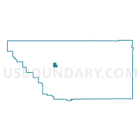
Voting District 40400, Kern County, California
About
Outline

Summary
| Unique Area Identifier | 531826 |
| Name | Voting District 40400 |
| County | Kern County |
| State | California |
| Area (square miles) | 15.30 |
| Land Area (square miles) | 15.30 |
| Water Area (square miles) | 0.00 |
| % of Land Area | 100.00 |
| % of Water Area | 0.00 |
| Latitude of the Internal Point | 35.38268560 |
| Longtitude of the Internal Point | -119.21956250 |
Maps


Graphs
Select a template below for downloading or customizing gragh for Voting District 40400, Kern County, California


Neighbors
Neighoring Voting District (by Name) Neighboring Voting District on the Map
- Voting District 10325, Kern County, CA
- Voting District 10330, Kern County, CA
- Voting District 10340, Kern County, CA
- Voting District 40370, Kern County, CA
- Voting District 40375, Kern County, CA
- Voting District 40405, Kern County, CA
- Voting District 40410, Kern County, CA
- Voting District 40415, Kern County, CA
- Voting District 40655, Kern County, CA
- Voting District 40675, Kern County, CA
- Voting District 40690, Kern County, CA
- Voting District 40720, Kern County, CA
- Voting District 40725, Kern County, CA
- Voting District 40745, Kern County, CA
- Voting District 40895, Kern County, CA
Top 10 Neighboring County Subdivision (by Population) Neighboring County Subdivision on the Map
- Rosedale CCD, Kern County, CA (70,154)
- Greenfield-Panama CCD, Kern County, CA (48,458)
- Buttonwillow CCD, Kern County, CA (3,953)
Top 10 Neighboring Place (by Population) Neighboring Place on the Map
Top 10 Neighboring Elementary School District (by Population) Neighboring Elementary School District on the Map
- Rosedale Union Elementary School District, CA (44,186)
- Rio Bravo-Greeley Union Elementary School District, CA (4,787)
Top 10 Neighboring Secondary School District (by Population) Neighboring Secondary School District on the Map
Top 10 Neighboring State Legislative District Lower Chamber (by Population) Neighboring State Legislative District Lower Chamber on the Map
Top 10 Neighboring State Legislative District Upper Chamber (by Population) Neighboring State Legislative District Upper Chamber on the Map
Top 10 Neighboring 111th Congressional District (by Population) Neighboring 111th Congressional District on the Map
Top 10 Neighboring Census Tract (by Population) Neighboring Census Tract on the Map
- Census Tract 38.09, Kern County, CA (10,984)
- Census Tract 32.04, Kern County, CA (9,386)
- Census Tract 38.03, Kern County, CA (4,769)
- Census Tract 37, Kern County, CA (3,953)